GROUND HERE: COLLABORATIVE WORKS OF KEN MCCOWN
DESIGN AND RESEARCH: URBAN, TRANSITION AND ERGONOMIC/BEHAVIORAL
This image demonstrates how students are able to connect scientific information with perception. Due to the power of photography databases, students can find perceptual images showing how the scientific information appears in their landscapes. The Sonoran Desert is interesting as a challenge to preconceptions as it is a five season landscape, noticeable through these images. (click to enlarge)
This page communicates a semester of study 'outside' of the city. To give a grounding in ecological literacy and sustainable design, students are challenged to do a 'landscape observatory.' They must create a design that reveals an ecological process, and model a twenty-four hour experience that includes sleeping, eating and bathing.
By looking at painting, students in the fourth year of landscape architecture and architecture become attuned to light and the beauty of moments. This opens up for them the idea that design can become background. It also heightens their perceptions, and shows them the power of position and moment that often eludes designers as a critical aspect of design.
Students then take several field trips to their sites to discover the places, and do scientific research to understand geomorphology, soils, climate and flora and fauna. After this foundation sets, student pick a process they feel defines their landscape. Then then model the process and the phenologies to see how elements work in time as well as space.
Precedents studies show students how design may be used to reveal processes. The combination of painting, scientific research, site visits, precedents studies, analysis and design modeled in scenarios of process and perception gives students a comprehensive study in ecological literacy and design.
Studies of paintings allow students to see how light, composition, placement and moments are used to create attractive, compelling and memorable images. Can design be thought of as background and choreography? (click image to enlarge)
Precedent studies show students how design can relate to ecological processes, and can take away preconceptions of what 'architecture' is. What is an appropriate level of design? (click image to enlarge)
Students study in teams a site with a foundation method for analyzing a landscape. Geomorphology and climate create soils, and flora and fauna live within that matrix. (click image to enlarge)
In this study of Red Rocks State Park in Arizona, the geomorphology and hydrology dramatically impact how the landscape functions. Also millions of years of history are exposed, and maps can now show where the location of the site was at any point in history along with the conditions of the planet at the time. (click image for lightbox view)
The geomorphology's impact on the landscape is shown in this diagram. The changes in parent material and elevation create three distinct plant communities. This creates a rich matrix of species. In these diagrams, students are challenged to see ecosystems as structure and function. For example, a tree is not a tree, it's a water pump, a habitat, a food source and an air exchanger. It's life intersects with a rich matrix of species. (click on image to see in lightbox)
After understanding the 'statics' of landscapes, students then examine the dynamics. Critical to ecosystem resilience is timing. If climate change alters temporal patterns, migrating species may miss important season events related to food supply. This may impact their rearing of young. Note the heavy gray line. It is the water supply. Note the winter rains and how they coincide with species migration. If the climate drivs out the landscape, there could be a species collapse. This water comes from snowmelt and rains from far away, so students can see relationships across scales. (click image to enlarge)
Brian Miller's observatory uses the trees in the riparian areas as indicators of ecological health. If they show certain habits throughout the years, the water supply is good. (click image to see bigger)
Brian's visitors to his observatory are not passive receivers of information. He challenges them to learn about how to read the trees, and gives them a kit. The kit helps visitors measure the trees and bring back information on their development to a log. Visitors can then look back through the log book and see how climate change may be affecting the water supply in the only riparian area in the region. (click image to enlarge)


Our studio typically does three to four sites per semester to give students an exposure to an array of landscapes. A few hours away from Red Rocks State Park, another group looked at the Organ Pipe Cactus National Park. It has some of the darkest skies in the Southwest. Dan Valenza's design was a 'moon observatory.' He used trips and Google Earth to find a point to marry the moon cycles and the landscapes. The moon will rise and set at distinct points viewers can notice. He faced a severe challenge with his remote location. How does one sleep, eat and bathe/use the restroom without any infrastructure? Dan's solution involved placing a prefab building at the base of the mountain where the observatory was located. The station on top of the mountain was built from rock fragments up there. (image is a gallery, click images to put into lightbox.)
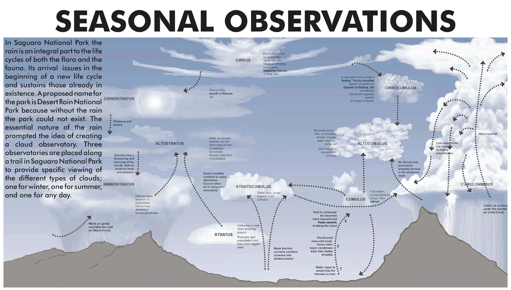


Heather Frost's observatory in Saguaro National Park addresses the distinguishing feature of the Sonoran Desert. It is the only desert with two rainy seasons, giving it is unique 'desert lush' appearance. She creates sky observation stations through Andy Goldsworthy type cuts into rocks. A delicate move in a sensitive landscape. Storms of different types form in different ways, and come from different directions in the summer and winter. She has a station for each, and also has a 'camera obscura' home station for sleeping, eating and bathing. A pin hole towards the sky of a buried structure casts an image of the sky on a limpid pool of water. Users can bathe in the sky. (gallery images, click each one tosee larger.)
More landscape perception work can be seen here. More observatory work is here.